Log in
All resources
Create a design
5,084 Free Artworks of Pages With Maps
maps from the earth and its inhabitants, vol. iv
maps from the earth and its inhabitants, vol. xiii
maps from the earth and its inhabitants, vol. xiv
maps from the earth and its inhabitants, vol. xviii
the comprehensive history of england (1876)
english-language maps showing history
1870s maps showing history
maps from the earth and its inhabitants, vol. x
maps from the earth and its inhabitants, vol. xvi
maps from the earth and its inhabitants, vol. xv
maps from the earth and its inhabitants, vol. iv
maps of falmouth, cornwall
maps from the earth and its inhabitants, vol. iv
old maps of leeds
maps from the earth and its inhabitants, vol. iv
old maps of sheffield
maps from the earth and its inhabitants, vol. iv
precipitation maps
maps from the earth and its inhabitants, vol. xiii
1878 maps of africa
maps from the earth and its inhabitants, vol. xviii
maps of weather and climate of south america
maps of ardabil province
maps of sabalan
maps from the earth and its inhabitants, vol. iv
old maps of leeds
maps from the earth and its inhabitants, vol. xiv
old maps of sydney
civitates orbis terrarum. urbium praecipuarum totius mundi. liber quartus
maps of sloten by braun & hogenberg
the comprehensive history of england (1876)
english-language maps showing history
the comprehensive history of england (1876)
english-language maps showing history
the comprehensive history of england (1876)
english-language maps showing history
the comprehensive history of england (1876)
english-language maps showing history
the comprehensive history of england (1876)
english-language maps showing history
flemish prints in the british museum
coenraed lauwers
maps from the earth and its inhabitants, vol. xiv
1870s maps of australia
maps from the earth and its inhabitants, vol. x
maps of lake victoria
maps from the earth and its inhabitants, vol. iv
bathymetric maps of the irish sea
maps from the earth and its inhabitants, vol. xii
19th-century maps of the azores
maps from the earth and its inhabitants, vol. iv
1870s maps of london
maps from the earth and its inhabitants, vol. xv
1870s maps of quebec
maps from the earth and its inhabitants, vol. xviii
maps of indigenous territories of colombia
maps from the earth and its inhabitants, vol. v
1870s maps of finland
maps from the earth and its inhabitants, vol. v
maps of spitsbergen
maps from the earth and its inhabitants, vol. xv
temperature maps of north america
maps from the earth and its inhabitants, vol. xvi
maps of the mexican war of independence
maps from the earth and its inhabitants, vol. xiv
old maps of sydney
maps from the earth and its inhabitants, vol. iv
old maps of the firth of forth
maps from the earth and its inhabitants, vol. xiv
1870s maps of australia
maps from the earth and its inhabitants, vol. xiii
maps indicating exploration
maps from the earth and its inhabitants, vol. iv
maps of the humber estuary
maps from the earth and its inhabitants, vol. viii
temperature maps
maps of borders of ecuador
1870s maps of ecuador
maps from the earth and its inhabitants, vol. iv
1870s maps of scotland
maps from the earth and its inhabitants, vol. iv
maps of guildford
maps from the earth and its inhabitants, vol. iv
19th-century maps of the english channel
maps from the earth and its inhabitants, vol. xvi
maps of central america
maps from the earth and its inhabitants, vol. iv
maps of rochester, kent
maps from the earth and its inhabitants, vol. iv
old maps of exeter
maps from the earth and its inhabitants, vol. xiii
1870s maps of africa
maps from the earth and its inhabitants, vol. iv
old maps of swansea
maps from the earth and its inhabitants, vol. iv
old maps of bristol
maps from the earth and its inhabitants, vol. vii
1870s maps of japan
maps from the earth and its inhabitants, vol. iv
19th-century maps of cornwall
maps from the earth and its inhabitants, vol. iv
1870s maps of scotland
maps from the earth and its inhabitants, vol. viii
maps of the mekong
19th-century maps of sierra leone
maps of rivers of sierra leone
maps from the earth and its inhabitants, vol. iii
population density maps of germany
civitates orbis terrarum. urbium praecipuarum totius mundi. liber quartus
maps of harlingen by braun & hogenberg
civitates orbis terrarum. urbium praecipuarum totius mundi. liber quartus
maps of malmö by braun & hogenberg
maps from the earth and its inhabitants, vol. x
1870s maps of egypt
maps from the earth and its inhabitants, vol. vi
population density maps of europe
maps from the earth and its inhabitants, vol. iv
1870s maps of london
maps from the earth and its inhabitants, vol. xviii
old maps of valparaíso
maps from the earth and its inhabitants, vol. viii
temperature maps
maps from the earth and its inhabitants, vol. xv
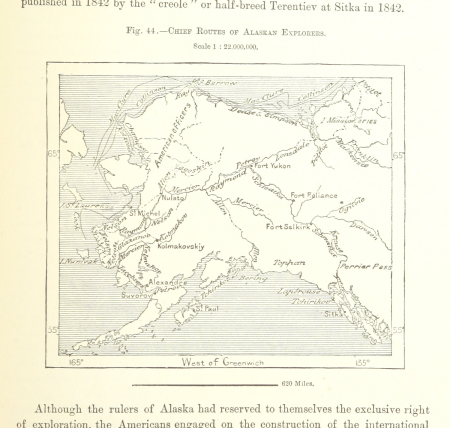
maps of the history of alaska
19th-century maps of namibia
maps of walvis bay
maps from the earth and its inhabitants, vol. xvi
old maps of central america
maps from the earth and its inhabitants, vol. iv
maps of snowdonia
maps from the earth and its inhabitants, vol. xvi
19th-century maps of mexico city
maps from the earth and its inhabitants, vol. xvi
1870s maps of mexico
maps from the earth and its inhabitants, vol. xviii
1870s maps of peru
maps from the earth and its inhabitants, vol. xii
maps of ocean currents
maps from the earth and its inhabitants, vol. iv
old maps of sunderland
maps from the earth and its inhabitants, vol. xi
1870s maps of algeria
maps from the earth and its inhabitants, vol. x
maps of weather and climate of africa
maps from the earth and its inhabitants, vol. iv
linguistic maps of ireland
maps from the earth and its inhabitants, vol. x
19th-century maps of the nile delta
maps from the earth and its inhabitants, vol. x
19th-century maps of the nile delta
maps from the earth and its inhabitants, vol. iv
drainage basin maps of the united kingdom
maps from the earth and its inhabitants, vol. iv
old maps of the river thames
maps from the earth and its inhabitants, vol. xv
1870s maps of quebec
maps from the earth and its inhabitants, vol. iv
1870s maps of wales
maps of natal colony
maps of zululand
a voyage to abyssinia, and travels into the interior of that country, executed under the orders of the british government in the years 1809 & 1810
john outhett
our arctic province, alaska and the seal islands (1886)
old maps of alaska
the comprehensive history of england (1876)
english-language maps showing history
maps from the earth and its inhabitants, vol. vii
treaty ports
maps from the earth and its inhabitants, vol. iv
bressay
maps from the earth and its inhabitants, vol. iv
illiteracy in the united kingdom
maps from the earth and its inhabitants, vol. iv
glenroy, scotland
maps from the earth and its inhabitants, vol. vi
naphtha
maps from the earth and its inhabitants, vol. xiii
topographic maps of angola
maps from the earth and its inhabitants, vol. iv
loch etive
spessartkarte 1594
paul pfinzing
with the armies of the balkans and at gallipoli (1880)
maps of the military history of bulgaria
december 1933 in washington, d.c.
public works of art project
maps from the earth and its inhabitants, vol. vi
shchurovsky glacier
maps from the earth and its inhabitants, vol. iii
old maps of halle (saale)
maps from the earth and its inhabitants, vol. ii
1874 maps
maps from the earth and its inhabitants, vol. iv
siornoway
maps from the earth and its inhabitants, vol. iv
holyhead
maps from the earth and its inhabitants, vol. xviii
treaty of tordesillas
maps from the earth and its inhabitants, vol. iv
peterhead
atlas sive cosmographicae (gerardus mercator, 1623)
maps of corsica by gerardus mercator
maps from the earth and its inhabitants, vol. iv
menai strait
transvaal gold fields
glossinidae
maps from the earth and its inhabitants, vol. xiii
1878 maps of africa
corona and coronet (1898)
1890s maps of japan
501 - 600 of 5,084
Next page
/ 51